Location
Our events take place in the Kowen Forest, 20 km east of Canberra, starting and finishing at the Wamboin Community Hall – 112 Bingley Way, Wamboin.
Accommodation
Are you from out of town and looking for accommodation while attending the Kowen Trail Run?
Why not stay at Queanbeyan: http://www.visitqueanbeyan.com.au/accommodation Queanbeyan is closer to Kowen Forest than Canberra and accommodation rates are FAR more reasonable!
Also, why not try searching for homes in Wamboin, or neighbouring areas of Bywong, Sutton, Bungendore and Queanbeyan on Airbnb at https://www.airbnb.com.au
Greenways
This page provides information on Wamboin’s network of ‘greenways’, public access trails that are ideal for trail running or walking. Please stick to the trails as they are bounded by, or close to, private property. The page also provides information on all major public entrances to Kowen Forest.
Click here for greenways brochure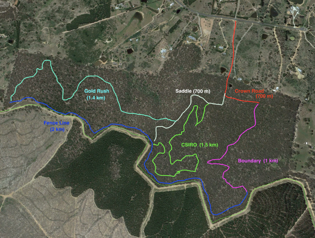
Map of Entrances to Kowen Forest 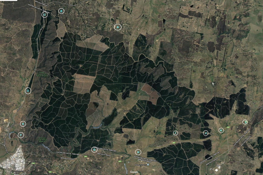
A = Bingley Way entrance – opposite 241 Bingley Way – familiar to Kowen Trail Run participants. There is a car park at the Community Hall. Referring to the map of forested land off Bingley Way (above), the main entrance to Kowen Forest is at the intersection of the Saddle, CSIRO and Fence line trails. There is also an entrance at the top of Poppet Hill next to the mobile tower (towards the end of the Fence line Trail, close to where it meets the Gold Rush Tail).
B = Cooper Rd entrance. Adjacent to 30 Cooper Road. Limited parking at gate.
C = Sutton Rd main entrance (Seven Mile Road). There is limited parking at the gate but additional parking 100 metres north of the gate, before the Norton Rd intersection. For more info, click here.
D = Sutton Rd mid-way. Limited parking just off the side of the road.
E = Kowen Rd main entrance. Off Sutton Road. Limited parking at gate. For more info, click here.
F = Molonglo Gorge entrance. Off Sutton Road. Car Park with Toilet and children’s playground. For more info, click here.
G = Off Ridgeway entrance. Off Kings Hwy. Limited parking at gate.
H = Glenburn Heritage Walk entrance. Off Kings Highway. Car park. For more info, click here.
I = Sparrow Hill entrance. Old Kings Highway West. Car park with toilet (some 200 metres from car park towards Sparrow Hill). For more info, click here.
J = Old Kings Highway East entrance. Car park.
K = Off the Defence roundabout entrance. Kings Highway. Limited parking at gate.
L = Opposite Brooks Hill Reserve entrance. Kings Highway. Limited parking at gate. For more info, click here.